|
|
Antenna Structure Registration 1011380 |
 |
Registration Info | Registration Number: 1011380 |
| File Number: A1057666 |
| FAA Study: 02-AWP-1224-OE |
| FAA Issue Date: 05/22/2002 |
| Status: Constructed |
| Date Constructed: 12/30/1986 |
| FAA EMI: N |
| NEPA: N |
Structure Info
| Structure Type: POLE |
| Structure Coordinates: 34-7-51.0 N 118-0-6.2 W (NAD 83) |
| Structure Coordinates: 34-07-51.0 N 118-00-03.0 W (Converted to NAD 27) |
| Structure Address: 1833 Santa Fe Place |
| Structure City: Monrovia, CA |
| Structure County: Los Angeles County |
| Painting & Lighting Info |
FAA Chapters: NONE |
Remarks: Removed expiration date from determination. Scenario 1./jjs/case#635066 |
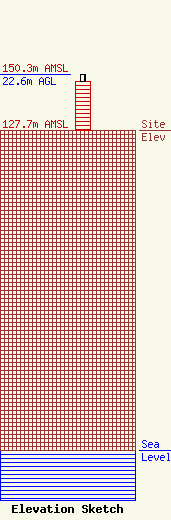
| Elevation Info |
Site Elevation: 127.7 meters (419 ft) |
| Height of Structure: 19.8 meters (65 feet) |
| Overall Height Above Ground: 22.6 meters (74 feet) |
| Overall Height Above Mean Sea Level: 150.3 meters (493 feet) |
| Owner Info | Los Angeles SMSA Limited Partnership
5055 North Point Pkwy
Alpharetta, GA 30022
(770) 797-1070
NetworkRegulatory@VerizonWireless.com |
| Contact Info | Los Angeles SMSA Limited Partnership
5055 North Point Pkwy
Alpharetta, GA 30022
Regulatory Manager
(770) 797-1070
NetworkRegulatory@VerizonWireless.com |
