|
|
Antenna Structure Registration 1011407 |
 |
Registration Info | Registration Number: 1011407 |
| File Number: A1381224 |
| FAA Study: 2018-ASW-2502-OE |
| FAA Issue Date: 03/22/2018 |
| Status: Constructed |
| Date Constructed: 04/27/2018 |
| NEPA: N |
Structure Info
| Structure Type: GTOWER |
| Structure Coordinates: 32-35-7.2 N 96-58-42.1 W (NAD 83) |
| Structure Coordinates: 32-35-06.7 N 96-58-41.1 W (Converted to NAD 27) |
| Structure Address: 1570 Beltline Rd |
| Structure City: Cedar Hill, TX |
| Structure County: Dallas County |
| Painting & Lighting Info |
FAA Circular #: 70/7460-1L |
FAA Chapters: 4, 9, 12 |
Remarks: PRIOR STUDY 1997-ASW-802-OE |
| Elevation Info |
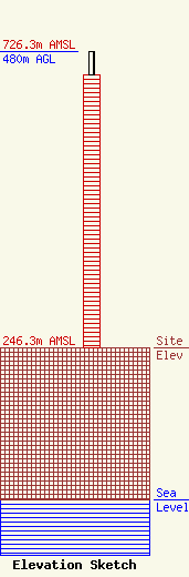
Site Elevation: 246.3 meters (808 ft) |
| Height of Structure: 443 meters (1453 feet) |
| Overall Height Above Ground: 480 meters (1575 feet) |
| Overall Height Above Mean Sea Level: 726.3 meters (2383 feet) |
| Owner Info | Hill Tower Corporation
8401 Greensboro Drive
McLean, VA 22102
(703) 873-6600
lawdept@tegna.com |
| Contact Info | TEGNA Inc.
8401 Greensboro Drive
McLean, VA 22102
Denise Branson
(703) 873-6606
dbranson@tegna.com |
