|
|
Antenna Structure Registration 1011420 |
 |
Registration Info | Registration Number: 1011420 |
| File Number: A1297289 |
| FAA Study: 91-AEA-1858-OE |
| FAA Issue Date: 01/01/1991 |
| Status: Constructed |
| Date Constructed: 06/01/1995 |
| FAA EMI: N |
| NEPA: N |
Structure Info
| Structure Type: TOWER |
| Structure Coordinates: 37-15-21.0 N 81-10-54.0 W (NAD 83) |
| Structure Coordinates: 37-15-20.6 N 81-10-54.7 W (Converted to NAD 27) |
| Structure Address: On East River Mountain On Rt 598 2.3 Mi Se |
| Structure City: Bluefield, WV |
| Structure County: Bland County |
| Painting & Lighting Info |
FAA Chapters: NONE |
| Elevation Info |
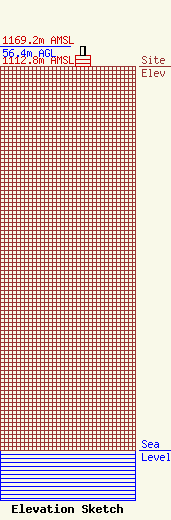
Site Elevation: 1112.8 meters (3651 ft) |
| Height of Structure: 30.4 meters (100 feet) |
| Overall Height Above Ground: 56.4 meters (185 feet) |
| Overall Height Above Mean Sea Level: 1169.2 meters (3836 feet) |
| Owner Info | Gray Local Media, Inc.
4370 Peachtree Road, NE
Atlanta, GA 30319
(404) 266-8333
legalnotices@graymedia.com |
| Contact Info | Gray Local Media, Inc.
4370 Peachtree Road NE
Atlanta, GA 30319
Engineering Department
(404) 266-8333
legalnotices@graymedia.com |
