|
|
Antenna Structure Registration 1011422 |
 |
Registration Info | Registration Number: 1011422 |
| File Number: A1384057 |
| FAA Study: 2015-AGL-11830-OE |
| FAA Issue Date: 09/24/2015 |
| Status: Constructed |
| Date Constructed: 09/01/1953 |
| NEPA: N |
Structure Info
| Structure Type: GTOWER |
| Structure Coordinates: 42-17-48.0 N 89-14-22.0 W (NAD 83) |
| Structure Coordinates: 42-17-47.9 N 89-14-21.6 W (Converted to NAD 27) |
| Structure Address: 10322 Auburn Rd |
| Structure City: Rockford, IL |
| Structure County: Winnebago County |
| Painting & Lighting Info |
FAA Circular #: 70/7460-1K |
FAA Chapters: 3, 4, 5, 12 |
Remarks: FAA CHAPTERS 3,4,5,12; 70/7460-1K WITH BIRD LIGHTING DEVIATION SPECIAL CONDITION. |
Remarks: Removed expiration date from determination. Scenario 1./jjs/case#635066 |
Remarks: FAA CHAPTERS 3,4,5,12; 70/7460-1K WITH BIRD LIGHTING DEVIATION SPECIAL CONDITION. |
Remarks: Removed expiration date from determination. Scenario 1./jjs/case#635066 |
| Elevation Info |
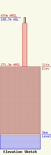
Site Elevation: 271.3 meters (890 ft) |
| Height of Structure: 175.6 meters (576 feet) |
| Overall Height Above Ground: 198.7 meters (652 feet) |
| Overall Height Above Mean Sea Level: 470 meters (1542 feet) |
| Owner Info | Gray Local Media, Inc.
4370 Peachtree Road NE
Atlanta, GA 30319
(404) 504-9828
allfcclms@gray.tv |
| Contact Info | Cooley LLP
1299 Pennsylvania Ave., NW
Washington, DC 20004
Henry Wendel
(202) 776-2943
hwendel@cooley.com |
