|
|
Antenna Structure Registration 1011488 |
 |
Registration Info | Registration Number: 1011488 |
| File Number: A1253725 |
| FAA Study: 2015-AWP-6655-OE |
| FAA Issue Date: 06/25/2015 |
| Status: Constructed |
| Date Constructed: 07/01/1982 |
| NEPA: N |
Structure Info
| Structure Type: LTOWER |
| Structure Coordinates: 32-41-51.0 N 116-56-5.7 W (NAD 83) |
| Structure Coordinates: 32-41-50.8 N 116-56-02.6 W (Converted to NAD 27) |
| Structure Address: 12197 Hwy 94 Bldg 3 |
| Structure City: Spring Valley, CA |
| Structure County: San Diego County |
| Painting & Lighting Info |
FAA Chapters: NONE |
| Elevation Info |
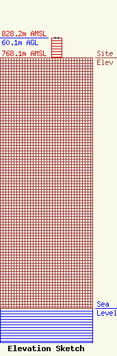
Site Elevation: 768.1 meters (2520 ft) |
| Height of Structure: 60.1 meters (197 feet) |
| Overall Height Above Ground: 60.1 meters (197 feet) |
| Overall Height Above Mean Sea Level: 828.2 meters (2717 feet) |
| Owner Info | Nexstar Media Inc.
545 E. John Carpenter Freeway
IRVING, TX 75062
(972) 373-8800
jasroberts@nexstar.tv |
| Contact Info | Nexstar Media Inc.
545 E. John Carpenter Freeway
IRVING, TX 75062
(972) 373-8800
jasroberts@nexstar.tv |
