|
|
Antenna Structure Registration 1011742 |
 |
Registration Info | Registration Number: 1011742 |
| File Number: A1322644 |
| FAA Study: 2016-AGL-13035-OE |
| FAA Issue Date: 09/14/2016 |
| Status: Constructed |
| Date Constructed: 09/17/1976 |
| NEPA: N |
Structure Info
| Structure Type: LTOWER |
| Structure Coordinates: 39-6-17.9 N 84-33-24.9 W (NAD 83) |
| Structure Coordinates: 39-06-17.7 N 84-33-25.1 W (Converted to NAD 27) |
| Structure Address: 2601 W 8th St & Matson Pl |
| Structure City: Cincinnati, OH |
| Structure County: Hamilton County |
| Painting & Lighting Info |
FAA Circular #: 70/7460-1L |
FAA Chapters: 3, 4, 5, 12 |
Remarks: PRIOR STUDY 2015-AGL-13088-OE |
| Elevation Info |
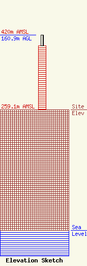
Site Elevation: 259.1 meters (850 ft) |
| Height of Structure: 137.6 meters (451 feet) |
| Overall Height Above Ground: 160.9 meters (528 feet) |
| Overall Height Above Mean Sea Level: 420 meters (1378 feet) |
| Owner Info | Vertical Bridge CC FM, LLC
22 W Atlantic Ave Suite 310
Delray Beach, FL 33444
(561) 405-4015
fcc-faa@verticalbridge.com |
| Contact Info | Vertical Bridge CC FM, LLC
22 W Atlantic Ave Suite 310
Delray Beach, FL 33444
Richard Hickey
(561) 405-4015
fcc-faa@verticalbridge.com |
