|
|
Antenna Structure Registration 1011870 |
 |
Registration Info | Registration Number: 1011870 |
| File Number: A1197646 |
| FAA Study: 2007-ASO-209-OE |
| FAA Issue Date: 02/02/2007 |
| Status: Constructed |
| Date Constructed: 02/01/1994 |
| NEPA: N |
Structure Info
| Structure Type: LTOWER |
| Structure Coordinates: 35-34-2.0 N 81-5-21.0 W (NAD 83) |
| Structure Coordinates: 35-34-01.5 N 81-05-21.7 W (Converted to NAD 27) |
| Structure Address: 3537 Tower Road (207930) |
| Structure City: Maiden, NC |
| Structure County: Catawba County |
| Painting & Lighting Info |
FAA Chapters: NONE |
Remarks: PRIOR STUDY 1996-ASO-5301-OE |
| Elevation Info |
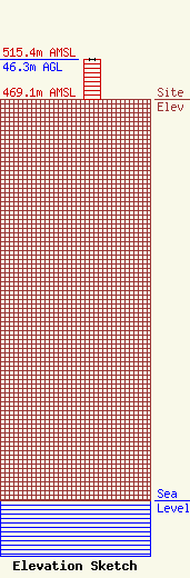
Site Elevation: 469.1 meters (1539 ft) |
| Height of Structure: 45.7 meters (150 feet) |
| Overall Height Above Ground: 46.3 meters (152 feet) |
| Overall Height Above Mean Sea Level: 515.4 meters (1691 feet) |
| Owner Info | American Towers LLC
10 Presidential Way
Woburn, MA 01801
(781) 926-4500
faa-fcc@americantower.com |
| Contact Info | American Towers LLC
10 Presidential Way
Woburn, MA 01801
(781) 926-4500
faa-fcc@americantower.com |
