|
|
Antenna Structure Registration 1011931 |
 |
Registration Info | Registration Number: 1011931 |
| File Number: A1341853 |
| FAA Study: 84-AGL-1080-OE |
| FAA Issue Date: 07/24/1984 |
| Status: Constructed |
| Date Constructed: 01/01/1984 |
| FAA EMI: N |
| NEPA: N |
Structure Info
| Structure Type: TOWER |
| Structure Coordinates: 40-36-23.0 N 89-32-20.0 W (NAD 83) |
| Structure Coordinates: 40-36-22.9 N 89-32-19.6 W (Converted to NAD 27) |
| Structure Address: Nw Corner Springfield Rd & Hwy 98 |
| Structure City: Groveland, IL |
| Structure County: Tazewell County |
| Painting & Lighting Info |
FCC Paragraph(s): 1, 3, 4, 13, 21 |
Remarks: RED LIGHTS/PAINT |
| Elevation Info |
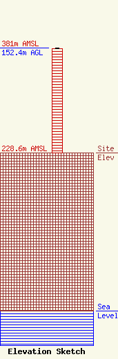
Site Elevation: 228.6 meters (750 ft) |
| Height of Structure: 151.2 meters (496 feet) |
| Overall Height Above Ground: 152.4 meters (500 feet) |
| Overall Height Above Mean Sea Level: 381 meters (1250 feet) |
| Owner Info | VB Nimbus, LLC
22 W Atlantic Avenue
Delray Beach, FL 33444
(561) 406-4015
fcc-faa@verticalbridge.com |
| Contact Info | VB Nimbus, LLC
22 W Atlantic Avenue
Delray Beach, FL 33444
Richard Hickey
(561) 406-4015
fcc-faa@verticalbridge.com |
