|
|
Antenna Structure Registration 1012232 |
 |
Registration Info | Registration Number: 1012232 |
| File Number: A0014653 |
| FAA Study: 91-AGL-2280-OE |
| FAA Issue Date: 01/02/1992 |
| Status: Constructed |
| Date Constructed: 04/01/1992 |
| NEPA: N |
Structure Info
| Structure Type: TOWER |
| Structure Coordinates: 38-37-47.0 N 90-0-40.0 W (NAD 83) |
| Structure Coordinates: 38-37-46.8 N 90-00-39.6 W (Converted to NAD 27) |
| Structure Address: 805 East O Fallon Dr |
| Structure City: Caseyville, IL |
| Structure County: St. Clair County |
| Painting & Lighting Info |
FAA Circular #: 70/7460-1H |
FAA Chapters: 3, 4, 5, 13 |
| Elevation Info |
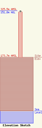
Site Elevation: 173.7 meters (570 ft) |
| Height of Structure: 147.8 meters (485 feet) |
| Overall Height Above Ground: 151.8 meters (498 feet) |
| Overall Height Above Mean Sea Level: 325.5 meters (1068 feet) |
| Owner Info | BARCOM INC
923 N BELT W
SWANSEA, IL 62221
(618) 277-3344
|
