|
|
Antenna Structure Registration 1012373 |
 |
Registration Info | Registration Number: 1012373 |
| File Number: A1063909 |
| FAA Study: 2012-AWP-4920-OE |
| FAA Issue Date: 07/25/2012 |
| Status: Constructed |
| Date Constructed: 01/01/1971 |
| FAA EMI: N |
| NEPA: N |
Structure Info
| Structure Type: LTOWER |
| Structure Coordinates: 36-17-15.7 N 118-50-23.3 W (NAD 83) |
| Structure Coordinates: 36-17-15.9 N 118-50-20.0 W (Converted to NAD 27) |
| Structure Address: On Blue Ridge, Approx. 10 Miles North Of Springville, California |
| Structure City: Springville, CA |
| Structure County: Tulare County |
| Painting & Lighting Info |
FAA Circular #: 70/7460-1K |
FAA Chapters: 3, 4, 5, 12 |
| Elevation Info |
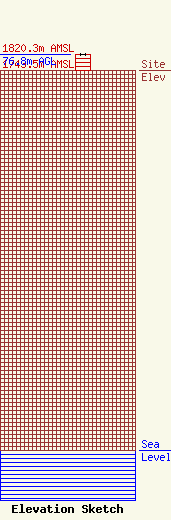
Site Elevation: 1743.5 meters (5720 ft) |
| Height of Structure: 76.8 meters (252 feet) |
| Overall Height Above Ground: 76.8 meters (252 feet) |
| Overall Height Above Mean Sea Level: 1820.3 meters (5972 feet) |
| Owner Info | Sinclair Television of Fresno, LLC
Pillsbury Winthrop Shaw Pittman LLP
Washington, DC 20036
(202) 663-8195
miles.mason@pillsburylaw.com |
| Contact Info | Sinclair Television of Fresno, LLC
Pillsbury Winthrop Shaw Pittman LLP
Washington, DC 20036
(202) 663-8195
miles.mason@pillsburylaw.com |
