|
|
Antenna Structure Registration 1012933 |
 |
Registration Info | Registration Number: 1012933 |
| File Number: A1379688 |
| FAA Study: 2026-ACE-818-OE |
| FAA Issue Date: 03/16/2026 |
| Status: Constructed |
| Date Constructed: 01/01/1965 |
| NEPA: N |
Structure Info
| Structure Type: GTOWER |
| Structure Coordinates: 37-4-34.9 N 94-32-16.4 W (NAD 83) |
| Structure Coordinates: 37-04-34.7 N 94-32-15.6 W (Converted to NAD 27) |
| Structure Address: 1928 West Thirteenth St. (306149 / Joplin 999) |
| Structure City: Joplin, MO |
| Structure County: Jasper County |
| Painting & Lighting Info |
FAA Circular #: 70/7460-1M |
FAA Chapters: 3, 4, 5, 15 |
Remarks: PRIOR STUDY 2017-ACE-2159-OE |
| Elevation Info |
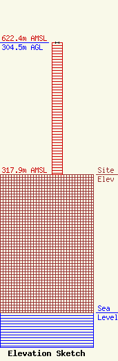
Site Elevation: 317.9 meters (1043 ft) |
| Height of Structure: 304.5 meters (999 feet) |
| Overall Height Above Ground: 304.5 meters (999 feet) |
| Overall Height Above Mean Sea Level: 622.4 meters (2042 feet) |
| Owner Info | American Towers LLC
10 Presidential Way
Woburn, MA 01801
(781) 926-4500
faa-fcc@americantower.com |
| Contact Info | American Towers LLC
10 Presidential Way
Woburn, MA 01801
(781) 926-4500
faa-fcc@americantower.com |
