|
|
Antenna Structure Registration 1013089 |
 |
Registration Info | Registration Number: 1013089 |
| File Number: A0015699 |
| FAA Study: 96-AWP-2358-OE |
| FAA Issue Date: 09/09/1996 |
| Status: Terminated |
| Date Constructed: 06/17/1996 |
| NEPA: N |
Structure Info
| Structure Type: POLE |
| Structure Coordinates: 34-11-59.0 N 118-10-37.0 W (NAD 83) |
| Structure Coordinates: 34-11-59.0 N 118-10-33.7 W (Converted to NAD 27) |
| Structure Address: 4815 Oak Grove Dr |
| Structure City: La Canada Flintridge, CA |
| Structure County: Los Angeles County |
| Painting & Lighting Info |
| Elevation Info |
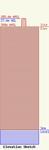
Site Elevation: 358 meters (1175 ft) |
| Height of Structure: 27.4 meters (90 feet) |
| Overall Height Above Ground: 27.4 meters (90 feet) |
| Overall Height Above Mean Sea Level: 385.4 meters (1264 feet) |
| Owner Info | PACIFIC BELL MOBILE SERVICES
4420 ROSEWOOD BLDG 2 4TH FL
PLEASANTON, CA 94588
(510) 227-3059
|
