|
|
Antenna Structure Registration 1013219 |
 |
Registration Info | Registration Number: 1013219 |
| File Number: A1380990 |
| FAA Study: 2015-AGL-17018-OE |
| FAA Issue Date: 12/09/2015 |
| Status: Constructed |
| Date Constructed: 01/09/2016 |
| NEPA: N |
Structure Info
| Structure Type: LTOWER |
| Structure Coordinates: 43-0-53.0 N 85-41-5.0 W (NAD 83) |
| Structure Coordinates: 43-00-52.9 N 85-41-04.9 W (Converted to NAD 27) |
| Structure Address: 645 Three Mile Rd Nw |
| Structure City: Walker, MI |
| Structure County: Kent County |
| Painting & Lighting Info |
FAA Circular #: 70/7460-1L |
FAA Chapters: 3, 4, 5, 12 |
Remarks: PRIOR STUDY 2015-AGL-6806-OE |
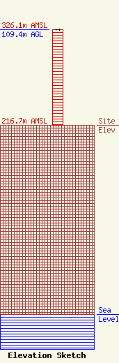
| Elevation Info |
Site Elevation: 216.7 meters (711 ft) |
| Height of Structure: 109 meters (358 feet) |
| Overall Height Above Ground: 109.4 meters (359 feet) |
| Overall Height Above Mean Sea Level: 326.1 meters (1070 feet) |
| Owner Info | Combined Communications of Oklahoma, LLC
8401 Greensboro Drive
McLean, VA 22102
(703) 873-6600
lawdept@tegna.com |
| Contact Info | TEGNA Inc.
8401 Greensboro Drive
McLean, VA 22102
Denise Branson
(703) 873-6606
dbranson@tegna.com |
