|
|
Antenna Structure Registration 1013390 |
 |
Registration Info | Registration Number: 1013390 |
| File Number: A0016038 |
| FAA Study: 84-AWP-869-OE |
| Status: Constructed |
| Date Constructed: 01/01/1984 |
| NEPA: N |
Structure Info
| Structure Type: TOWER |
| Structure Coordinates: 34-13-45.0 N 118-4-7.0 W (NAD 83) |
| Structure Coordinates: 34-13-45.0 N 118-04-03.8 W (Converted to NAD 27) |
| Structure Address: Mount Wilson Antenna Farms |
| Structure City: Mount Wilson, CA |
| Structure County: Los Angeles County |
| Painting & Lighting Info |
FAA Chapters: NONE |
| Elevation Info |
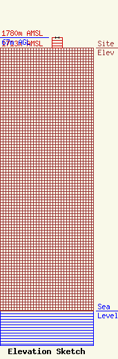
Site Elevation: 1713 meters (5620 ft) |
| Height of Structure: 67 meters (220 feet) |
| Overall Height Above Ground: 67 meters (220 feet) |
| Overall Height Above Mean Sea Level: 1780 meters (5840 feet) |
| Owner Info | MOUNT WILSON FM BROADCASTERS INC DBA = KKGO FM
1500 COTNER ST
250028
LOS ANGELES, CA 90025
(310) 478-5540
|
