|
|
Antenna Structure Registration 1013428 |
 |
Registration Info | Registration Number: 1013428 |
| File Number: A1253560 |
| FAA Study: 2022-AWP-18520-OE |
| FAA Issue Date: 10/12/2022 |
| Status: Constructed |
| Date Constructed: 06/02/2023 |
| NEPA: N |
Structure Info
| Structure Type: MTOWER |
| Structure Coordinates: 34-6-28.0 N 118-1-26.4 W (NAD 83) |
| Structure Coordinates: 34-06-28.0 N 118-01-23.2 W (Converted to NAD 27) |
| Structure Address: 206 East Live Oak Avenue |
| Structure City: Arcadia, CA |
| Structure County: Los Angeles County |
| Painting & Lighting Info |
FAA Chapters: NONE |
Remarks: PRIOR STUDY 2022-AWP-9774-OE |
| Elevation Info |
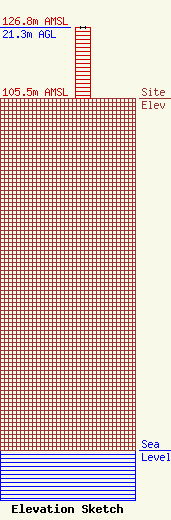
Site Elevation: 105.5 meters (346 ft) |
| Height of Structure: 21.3 meters (70 feet) |
| Overall Height Above Ground: 21.3 meters (70 feet) |
| Overall Height Above Mean Sea Level: 126.8 meters (416 feet) |
| Owner Info | CCATT LLC
2000 Corporate Drive
Canonsburg, PA 15317
(724) 416-2000
Regulatory.Department@Crowncastle.com |
| Contact Info | Crown Castle
2000 Corporate Drive
Canonsburg, PA 15317
Don Snyder
(724) 416-2470
Don.Snyder@crowncastle.com |
