|
|
Antenna Structure Registration 1013742 |
 |
Registration Info | Registration Number: 1013742 |
| File Number: A0789532 |
| FAA Study: 88-AGL-851-OE |
| FAA Issue Date: 07/12/1988 |
| Status: Constructed |
| Date Constructed: 01/01/1988 |
| FAA EMI: N |
| NEPA: N |
Structure Info
| Structure Type: TOWER |
| Structure Coordinates: 41-7-4.0 N 83-32-38.0 W (NAD 83) |
| Structure Coordinates: 41-07-03.8 N 83-32-38.3 W (Converted to NAD 27) |
| Structure Address: Cass Twp Rd 247 .6 Km S Of Cr 109 |
| Structure City: Cass Township, OH |
| Structure County: Hancock County |
| Painting & Lighting Info |
FAA Circular #: 70/7460-1G |
FAA Chapters: 3, 4, 5, 9 |
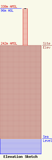
| Elevation Info |
Site Elevation: 242 meters (794 ft) |
| Height of Structure: 95 meters (312 feet) |
| Overall Height Above Ground: 96 meters (315 feet) |
| Overall Height Above Mean Sea Level: 338 meters (1109 feet) |
| Owner Info | University of Findlay
1000 N Main Street
Findlay, OH 45840
(419) 434-6947
beck@findlay.edu |
| Contact Info | Attorney
11464 Saga Lane
Knoxville, TN 37931-2819
Larry Perry
(865) 927-8474
larryperry@att.net |
