|
|
Antenna Structure Registration 1013831 |
 |
Registration Info | Registration Number: 1013831 |
| File Number: A1114975 |
| FAA Study: 2018-AGL-16540-OE |
| FAA Issue Date: 09/11/2018 |
| Status: Constructed |
| Date Constructed: 05/17/1973 |
| NEPA: N |
Structure Info
| Structure Type: GTOWER |
| Structure Coordinates: 41-48-58.3 N 80-46-48.6 W (NAD 83) |
| Structure Coordinates: 41-48-58.1 N 80-46-49.3 W (Converted to NAD 27) |
| Structure Address: 3226 Jefferson Rd (204134) |
| Structure City: Ashtabula, OH |
| Structure County: Ashtabula County |
| Painting & Lighting Info |
FCC Paragraph(s): 1, 3, 4, 13, 21 |
Remarks: Continue As Is OM&L = PAINT/RED LIGHTS |
Remarks: PRIOR STUDY 1999-AGL-4792-OE |
Remarks: Continue As Is OM&L = PAINT/RED LIGHTS |
Remarks: PRIOR STUDY 1999-AGL-4792-OE |
| Elevation Info |
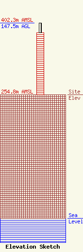
Site Elevation: 254.8 meters (836 ft) |
| Height of Structure: 128 meters (420 feet) |
| Overall Height Above Ground: 147.5 meters (484 feet) |
| Overall Height Above Mean Sea Level: 402.3 meters (1320 feet) |
| Owner Info | American Towers LLC
10 Presidential Way
Woburn, MA 01801
(781) 926-4500
faa-fcc@americantower.com |
| Contact Info | American Towers, LLC
10 Presidential Way
Woburn, MA 01801
(781) 926-4500
faa-fcc@americantower.com |
