|
|
Antenna Structure Registration 1014010 |
 |
Registration Info | Registration Number: 1014010 |
| File Number: A1137074 |
| FAA Study: 88-AWP-863-OE |
| FAA Issue Date: 12/28/1988 |
| Status: Constructed |
| Date Constructed: 10/27/1999 |
| FAA EMI: N |
| NEPA: N |
Structure Info
|
| Structure Coordinates: 34-31-32.0 N 119-57-32.0 W (NAD 83) |
| Structure Coordinates: 34-31-32.0 N 119-57-28.5 W (Converted to NAD 27) |
| Structure Address: Broadcast Peak 1.2 Mi E Of Santa Ynez Mountains |
| Structure City: Santa Barbara, CA |
| Structure County: Santa Barbara County |
| Painting & Lighting Info |
FCC Paragraph(s): 1, 3, 11, 21 |
Remarks: RED LIGHTS/PAINT |
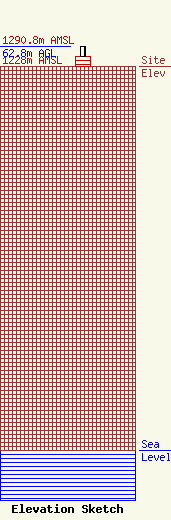
| Elevation Info |
Site Elevation: 1228 meters (4029 ft) |
| Height of Structure: 30.5 meters (100 feet) |
| Overall Height Above Ground: 62.8 meters (206 feet) |
| Overall Height Above Mean Sea Level: 1290.8 meters (4235 feet) |
| Owner Info | NPG of California, LLC
825 Edmond Street
Saint Joseph, MO 64501
(816) 271-8505
jim.dechant@npgco.com |
| Contact Info | NPG of California, LLC
825 Edmond Street
Saint Joseph, MO 64501
Jim DeChant
(816) 271-8505
jim.dechant@npgco.com |
