|
|
Antenna Structure Registration 1014093 |
 |
Registration Info | Registration Number: 1014093 |
| File Number: A0016882 |
| FAA Study: 87-ASW-0374-OE |
| FAA Issue Date: 05/04/1987 |
| Status: Terminated |
| Date Constructed: 01/01/1992 |
| NEPA: N |
Structure Info
| Structure Type: TOWER |
| Structure Coordinates: 34-47-56.0 N 92-29-45.0 W (NAD 83) |
| Structure Coordinates: 34-47-55.7 N 92-29-44.4 W (Converted to NAD 27) |
| Structure Address: Shinnal Mountain |
| Structure City: Little Rock, AR |
| Structure County: Pulaski County |
| Painting & Lighting Info |
FAA Circular #: 70/7460-1G |
FAA Chapters: 4, 6, 9 |
| Elevation Info |
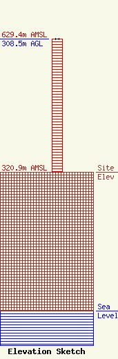
Site Elevation: 320.9 meters (1053 ft) |
| Height of Structure: 308.5 meters (1012 feet) |
| Overall Height Above Ground: 308.5 meters (1012 feet) |
| Overall Height Above Mean Sea Level: 629.4 meters (2065 feet) |
| Owner Info | SIGNAL MEDIA OF ARKANSAS INC
2400 COTTONDALE LANE
LITTLE ROCK, AR 72202
(501) 664-9410
NORM@INTELLINET.COM |
