|
|
Antenna Structure Registration 1014360 |
 |
Registration Info | Registration Number: 1014360 |
| File Number: A1337883 |
| FAA Study: 2014-AWP-7316-OE |
| FAA Issue Date: 10/24/2014 |
| Status: Constructed |
| Date Constructed: 01/01/1975 |
| NEPA: N |
Structure Info
| Structure Type: B |
| Structure Coordinates: 34-6-13.7 N 118-5-29.0 W (NAD 83) |
| Structure Coordinates: 34-06-13.7 N 118-05-25.8 W (Converted to NAD 27) |
| Structure Address: 105 N San Gabriel Blvd |
| Structure City: San Gabriel, CA |
| Structure County: Los Angeles County |
| Painting & Lighting Info |
FAA Chapters: NONE |
Remarks: PRIOR STUDY 1996-AWP-1844-OE |
| Elevation Info |
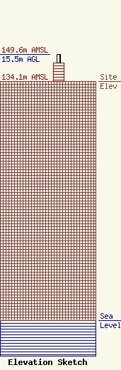
Site Elevation: 134.1 meters (440 ft) |
| Height of Structure: 10.7 meters (35 feet) |
| Overall Height Above Ground: 15.5 meters (51 feet) |
| Overall Height Above Mean Sea Level: 149.6 meters (491 feet) |
| Owner Info | Pacific Bell Telephone Company d/b/a AT&T California
3400 W Plano Pkwy
Plano, TX 75075
(855) 699-7073
ATTNRC@att.com |
| Contact Info | AT&T Mobility Services LLC
3400 W Plano Pkwy
Plano, TX 75075
Jaime Ochoa
(855) 699-7073
ATTNRC@att.com |
