|
|
Antenna Structure Registration 1014519 |
 |
Registration Info | Registration Number: 1014519 |
| File Number: A1384275 |
| FAA Study: 2020-AGL-7675-OE |
| FAA Issue Date: 05/20/2020 |
| Status: Constructed |
| Date Constructed: 12/01/2004 |
| NEPA: N |
Structure Info
| Structure Type: GTOWER |
| Structure Coordinates: 40-44-51.2 N 84-7-54.3 W (NAD 83) |
| Structure Coordinates: 40-44-51.0 N 84-07-54.5 W (Converted to NAD 27) |
| Structure Address: 1424 Rice Ave |
| Structure City: Lima, OH |
| Structure County: Allen County |
| Painting & Lighting Info |
FAA Circular #: 70/7460-1L |
FAA Chapters: 4, 8, 12 |
Remarks: OM&L to remain the same as prior study = A MED-DUAL SYSTEM |
Remarks: PRIOR STUDY 2019-AGL-7218-OE |
Remarks: OM&L to remain the same as prior study = A MED-DUAL SYSTEM |
Remarks: PRIOR STUDY 2019-AGL-7218-OE |
| Elevation Info |
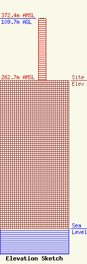
Site Elevation: 262.7 meters (862 ft) |
| Height of Structure: 109.7 meters (360 feet) |
| Overall Height Above Ground: 109.7 meters (360 feet) |
| Overall Height Above Mean Sea Level: 372.4 meters (1222 feet) |
| Owner Info | Gray Local Media, Inc.
4370 Peachtree Road, NE
Atlanta, GA 30319
(404) 266-8333
legalnotices@graymedia.com |
| Contact Info | Gray Local Media, Inc.
4370 Peachtree Road NE
Atlanta, GA 30319
Engineering Department
(404) 266-8333
legalnotices@graymedia.com |
