|
|
Antenna Structure Registration 1014557 |
 |
Registration Info | Registration Number: 1014557 |
| File Number: A1122548 |
| FAA Study: 90-AGL-641-OE |
| FAA Issue Date: 04/16/1990 |
| Status: Constructed |
| Date Constructed: 01/01/1981 |
| FAA EMI: N |
| NEPA: N |
Structure Info
| Structure Type: TOWER |
| Structure Coordinates: 41-9-39.0 N 87-52-30.0 W (NAD 83) |
| Structure Coordinates: 41-09-38.9 N 87-52-29.8 W (Converted to NAD 27) |
| Structure Address: 292 N Convent |
| Structure City: Bourbonnais, IL |
| Structure County: Kankakee County |
| Painting & Lighting Info |
FCC Paragraph(s): 1, 3, 11, 21 |
Remarks: RED LIGHTS/PAINT |
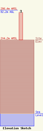
| Elevation Info |
Site Elevation: 204.2 meters (670 ft) |
| Height of Structure: 76.2 meters (250 feet) |
| Overall Height Above Ground: 82.2 meters (270 feet) |
| Overall Height Above Mean Sea Level: 286.4 meters (940 feet) |
| Owner Info | Milner Media Partners, LLC
292 N. Convent
758
BOURBONNAIS, IL 60914
(815) 933-9287
doit1231@aol.com |
| Contact Info | Milner Media Partners, LLC
292 N. Convent
758
BOURBONNAIS, IL 60914
Tim Milner
(815) 933-9287
doit1231@aol.com |
