|
|
Antenna Structure Registration 1014586 |
 |
Registration Info | Registration Number: 1014586 |
| File Number: A1261616 |
| FAA Study: 2010-ASO-6528-OE |
| FAA Issue Date: 01/23/2011 |
| Status: Constructed |
| Date Constructed: 01/23/2011 |
| NEPA: N |
Structure Info
| Structure Type: LTOWER |
| Structure Coordinates: 36-3-51.3 N 79-48-35.2 W (NAD 83) |
| Structure Coordinates: 36-03-50.8 N 79-48-36.1 W (Converted to NAD 27) |
| Structure Address: Corner Forest Ave & Oakland St |
| Structure City: Greensboro, NC |
| Structure County: Guilford County |
| Painting & Lighting Info |
FAA Chapters: NONE |
Remarks: PRIOR STUDY 2009-ASO-2693-OE |
| Elevation Info |
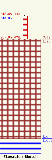
Site Elevation: 257.8 meters (846 ft) |
| Height of Structure: 61 meters (200 feet) |
| Overall Height Above Ground: 61 meters (200 feet) |
| Overall Height Above Mean Sea Level: 318.8 meters (1046 feet) |
| Owner Info | UNIVERSITY OF NORTH CAROLINA
10 UNC-TV DRIVE
14900
RESEARCH TRIANGLE PK, NC 27709
(919) 549-7000
fcc_notice@pbsnc.org |
| Contact Info | University of North Carolina
10 UNC-TV Drive
14900
Research Triangle Pk, NC 27709
Donald Smith
(919) 549-7025
dsmith@pbsnc.org |
