|
|
Antenna Structure Registration 1014588 |
 |
Registration Info | Registration Number: 1014588 |
| File Number: A0907730 |
| FAA Study: 69-AT-0156 |
| FAA Issue Date: 08/10/1998 |
| Status: Dismantled |
| Date Constructed: 07/12/1999 |
| FAA EMI: N |
| NEPA: N |
Structure Info
| Structure Type: TOWER |
| Structure Coordinates: 34-37-47.0 N 78-6-32.0 W (NAD 83) |
| Structure Coordinates: 34-37-46.4 N 78-06-33.0 W (Converted to NAD 27) |
| Structure Address: S Of Int Hwys 11 & 421 3 Mi W |
| Structure City: Penderlea, NC |
| Structure County: Pender County |
| Painting & Lighting Info |
FAA Circular #: 70/7460-1J |
FAA Chapters: 4, 6, 13 |
| Elevation Info |
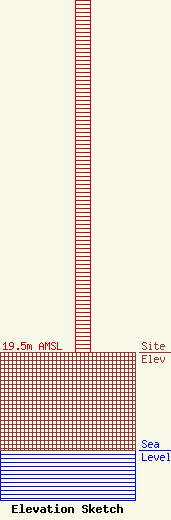
Site Elevation: 19.5 meters (64 ft) |
| Height of Structure: 77.7 meters (255 feet) |
| Overall Height Above Ground: 77.7 meters (255 feet) |
| Overall Height Above Mean Sea Level: 97.2 meters (319 feet) |
| Owner Info | UNIVERSITY OF NORTH CAROLINA
10 T W ALEXANDER DR
14900
RESEARCH TRIANGLE PA, NC 27709
(919) 549-7263
|
