|
|
Antenna Structure Registration 1014869 |
 |
Registration Info | Registration Number: 1014869 |
| File Number: A1054791 |
| FAA Study: 83-AWP-599-OE |
| FAA Issue Date: 06/01/1983 |
| Status: Constructed |
| Date Constructed: 08/01/1984 |
| FAA EMI: N |
| NEPA: N |
Structure Info
| Structure Type: TOWER |
| Structure Coordinates: 40-44-27.0 N 124-12-9.0 W (NAD 83) |
| Structure Coordinates: 40-44-27.5 N 124-12-04.8 W (Converted to NAD 27) |
| Structure Address: 5640 S Broadway |
| Structure City: Eureka, CA |
| Structure County: Humboldt County |
| Painting & Lighting Info |
FAA Circular #: 70/7460-1F |
FAA Chapters: 3, 4, 5 |
Remarks: RED LIGHTS/PAINT |
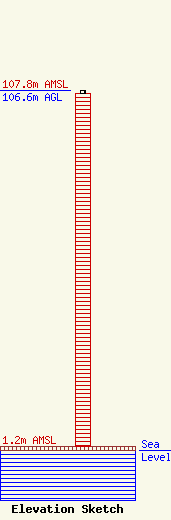
| Elevation Info |
Site Elevation: 1.2 meters (4 ft) |
| Height of Structure: 105.7 meters (347 feet) |
| Overall Height Above Ground: 106.6 meters (350 feet) |
| Overall Height Above Mean Sea Level: 107.8 meters (354 feet) |
| Owner Info | Bicoastal Nor Cal, LLC
One Blackfield Drive
Tiburon, CA 94920
(415) 789-5035
kevin@bicoastalmedia.com |
| Contact Info | Bicoastal Media
One Blackfield Drive
Tiburon, CA 94920
Kevin Mostyn
(415) 789-5035
kevin@bicoastalmedia.com |
