|
|
Antenna Structure Registration 1015353 |
 |
Registration Info | Registration Number: 1015353 |
| File Number: A0977422 |
| Status: Constructed |
| Date Constructed: 01/01/1954 |
| FAA EMI: N |
| NEPA: N |
Structure Info
| Structure Type: 2TOWER |
| Structure Coordinates: 34-13-29.0 N 118-3-49.0 W (NAD 83) |
| Structure Coordinates: 34-13-29.0 N 118-03-45.8 W (Converted to NAD 27) |
| Structure Address: Mount Wilson 15.7 Mi Ne |
| Structure City: Los Angeles, CA |
| Structure County: Los Angeles County |
| Painting & Lighting Info |
FCC Paragraph(s): None |
| Elevation Info |
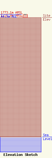
Site Elevation: 1728.8 meters (5672 ft) |
| Height of Structure: 44.3 meters (145 feet) |
| Overall Height Above Ground: 44.3 meters (145 feet) |
| Overall Height Above Mean Sea Level: 1773.1 meters (5817 feet) |
| Owner Info | Fox Television Stations, LLC
400 N. Capitol Street, NW
Washington, DC 20001
(202) 824-6522
jdiscipio@21cf.com |
| Contact Info | Fox Television Stations, LLC
400 N. Capitol Street, NW
Washington, DC 20001
(202) 824-6522
jdiscipio@21cf.com |
