|
|
Antenna Structure Registration 1015485 |
 |
Registration Info | Registration Number: 1015485 |
| File Number: A1311908 |
| FAA Study: 2025-AWP-3640-OE |
| FAA Issue Date: 04/09/2025 |
| Status: Constructed |
| Date Constructed: 01/01/2002 |
| NEPA: N |
Structure Info
| Structure Type: MTOWER |
| Structure Coordinates: 34-13-43.0 N 118-4-4.9 W (NAD 83) |
| Structure Coordinates: 34-13-43.0 N 118-04-01.7 W (Converted to NAD 27) |
| Structure Address: 1075 Red Box Rd (ca189a2-a Mt Wilson 3) |
| Structure City: Mt Wilson, CA |
| Structure County: Los Angeles County |
| Painting & Lighting Info |
FAA Chapters: NONE |
| Elevation Info |
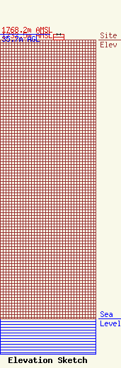
Site Elevation: 1732.5 meters (5684 ft) |
| Height of Structure: 34.1 meters (112 feet) |
| Overall Height Above Ground: 35.7 meters (117 feet) |
| Overall Height Above Mean Sea Level: 1768.2 meters (5801 feet) |
| Owner Info | SBA Towers XI, LLC
8051 Congress Avenue
Boca Raton, FL 33487
(561) 995-7670
ERoach@sbasite.com |
| Contact Info | SBA Towers XI, LLC
8051 Congress Avenue
Boca Raton, FL 33487
(561) 995-7670
ERoach@sbasite.com |
