|
|
Antenna Structure Registration 1015745 |
 |
Registration Info | Registration Number: 1015745 |
| File Number: A1229724 |
| FAA Study: 2021-AGL-28532-OE |
| FAA Issue Date: 10/24/2022 |
| Status: Constructed |
| Date Constructed: 11/15/1976 |
| NEPA: N |
Structure Info
| Structure Type: LTOWER |
| Structure Coordinates: 41-3-31.9 N 80-38-46.3 W (NAD 83) |
| Structure Coordinates: 41-03-31.7 N 80-38-47.0 W (Converted to NAD 27) |
| Structure Address: 3930 Sunset Blvd(307644) |
| Structure City: Youngstown, OH |
| Structure County: Mahoning County |
| Painting & Lighting Info |
FAA Circular #: 70/7460-1L |
FAA Chapters: 4, 8, 12 |
Remarks: PRIOR STUDY 2019-AGL-16638-OE |
Remarks: OM&L to remain the same as prior study = A MED-DUAL SYSTEM |
Remarks: PRIOR STUDY 2019-AGL-16638-OE |
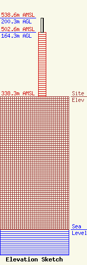
| Elevation Info |
Site Elevation: 338.3 meters (1110 ft) |
| Height of Structure: 164.3 meters (539 feet) |
| Overall Height Above Ground: 200.3 meters (657 feet) |
| Overall Height Above Mean Sea Level: 538.6 meters (1767 feet) |
| Owner Info | American Towers, LLC
10 Presidential Way
Woburn, MA 01801
(781) 926-4500
faa-fcc@americantower.com |
| Contact Info | American Towers, LLC
10 Presidential Way
Woburn, MA 01801
(781) 926-4500
faa-fcc@americantower.com |
