|
|
Antenna Structure Registration 1016049 |
 |
Registration Info | Registration Number: 1016049 |
| File Number: A0079759 |
| FAA Study: 97-AGL-0195-OE |
| FAA Issue Date: 01/01/1997 |
| Status: Constructed |
| Date Constructed: 01/01/1948 |
| NEPA: N |
Structure Info
| Structure Type: TOWER |
| Structure Coordinates: 39-43-17.0 N 84-8-59.0 W (NAD 83) |
| Structure Coordinates: 39-43-16.8 N 84-08-59.2 W (Converted to NAD 27) |
| Structure Address: 1414 Wilmington Ave |
| Structure City: Dayton, OH |
| Structure County: Montgomery County |
| Painting & Lighting Info |
FAA Circular #: 70/7460-1J |
FAA Chapters: 3, 4, 5, 13 |
Remarks: RED LIGHTS/PAINT |
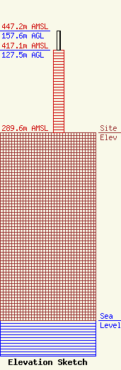
| Elevation Info |
Site Elevation: 289.6 meters (950 ft) |
| Height of Structure: 127.5 meters (418 feet) |
| Overall Height Above Ground: 157.6 meters (517 feet) |
| Overall Height Above Mean Sea Level: 447.2 meters (1467 feet) |
| Owner Info | MIAMI VALLEY BROADCASTING CORPORATION
1414 WILMINGTON AVE
DAYTON, OH 45401
(937) 259-2092
|
