|
|
Antenna Structure Registration 1016253 |
 |
Registration Info | Registration Number: 1016253 |
| File Number: A0019482 |
| FAA Study: 83-ASO-355-OE |
| FAA Issue Date: 02/23/1983 |
| Status: Constructed |
| Date Constructed: 01/01/1983 |
| NEPA: N |
Structure Info
| Structure Type: TOWER |
| Structure Coordinates: 31-15-50.0 N 82-17-29.0 W (NAD 83) |
| Structure Coordinates: 31-15-49.2 N 82-17-29.6 W (Converted to NAD 27) |
| Structure Address: Us Hwy 82 1.8 Km Sw Of Homestead |
| Structure City: Blackshear, GA |
| Structure County: Pierce County |
| Painting & Lighting Info |
FAA Circular #: 70/7460-1F |
FAA Chapters: 3, 4, 5, 9 |
| Elevation Info |
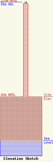
Site Elevation: 42 meters (138 ft) |
| Height of Structure: 90 meters (295 feet) |
| Overall Height Above Ground: 91 meters (299 feet) |
| Overall Height Above Mean Sea Level: 133 meters (436 feet) |
| Owner Info | MATTOX, G TROY DBA = WKUB RADIO
22
BLACKSHEAR, GA 31516
(912) 449-3391
|
