|
|
Antenna Structure Registration 1016457 |
 |
Registration Info | Registration Number: 1016457 |
| File Number: A1235409 |
| FAA Study: 2021-ASO-25036-OE |
| FAA Issue Date: 11/16/2021 |
| Status: Constructed |
| Date Constructed: 07/01/1988 |
Structure Info
| Structure Type: GTOWER |
| Structure Coordinates: 30-16-36.8 N 81-33-57.0 W (NAD 83) |
| Structure Coordinates: 30-16-35.9 N 81-33-57.7 W (Converted to NAD 27) |
| Structure Address: 9050 Hogan Road (#207748) |
| Structure City: Jacksonville, FL |
| Structure County: Duval County |
| Painting & Lighting Info |
FAA Circular #: 70/7460-1M |
FAA Chapters: 4, 9, 15 |
Remarks: PRIOR STUDY 1988-ASO-1533-OE |
| Elevation Info |
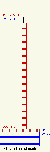
Site Elevation: 7.9 meters (26 ft) |
| Height of Structure: 289.8 meters (951 feet) |
| Overall Height Above Ground: 305.3 meters (1002 feet) |
| Overall Height Above Mean Sea Level: 313.2 meters (1028 feet) |
| Owner Info | American Towers LLC
10 Presidential Way
Woburn, MA 01801
(781) 926-4500
faa-fcc@americantower.com |
| Contact Info | American Towers LLC
10 Presidential Way
Woburn, MA 01801
(781) 926-4500
faa-fcc@americantower.com |
