|
|
Antenna Structure Registration 1016546 |
 |
Registration Info | Registration Number: 1016546 |
| File Number: A1064023 |
| Status: Constructed |
| Date Constructed: 05/31/1983 |
| FAA EMI: N |
| NEPA: N |
Structure Info
| Structure Type: TOWER |
| Structure Coordinates: 37-18-55.0 N 79-38-5.0 W (NAD 83) |
| Structure Coordinates: 37-18-54.5 N 79-38-05.9 W (Converted to NAD 27) |
| Structure Address: Atop Flat Top Mountain 2.8 Mi Ssw |
| Structure City: Thaxton, VA |
| Structure County: Bedford County |
| Painting & Lighting Info |
FCC Paragraph(s): A1, B, E, H |
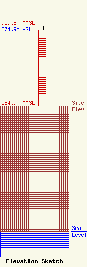
| Elevation Info |
Site Elevation: 584.9 meters (1919 ft) |
| Height of Structure: 353.7 meters (1160 feet) |
| Overall Height Above Ground: 374.9 meters (1230 feet) |
| Overall Height Above Mean Sea Level: 959.8 meters (3149 feet) |
| Owner Info | WSET Licensee, LLC
Pillsbury Winthrop Shaw Pittman LLP
Washington, DC 20036
(202) 663-8195
miles.mason@pillsburylaw.com |
| Contact Info | WSET Licensee, LLC
Pillsbury Winthrop Shaw Pittman LLP
Washington, DC 20036
(202) 663-8195
miles.mason@pillsburylaw.com |
