|
|
Antenna Structure Registration 1016803 |
 |
Registration Info | Registration Number: 1016803 |
| File Number: A1367641 |
| FAA Study: 2011-ANE-896-OE |
| FAA Issue Date: 05/13/2011 |
| Status: Constructed |
| Date Constructed: 04/07/1999 |
| FAA EMI: N |
| NEPA: N |
Structure Info
| Structure Type: TOWER |
| Structure Coordinates: 43-57-4.4 N 70-17-44.8 W (NAD 83) |
| Structure Coordinates: 43-57-04.1 N 70-17-46.6 W (Converted to NAD 27) |
| Structure Address: Gloucester Hill Rd |
| Structure City: New Gloucester, ME |
| Structure County: Cumberland County |
| Painting & Lighting Info |
FCC Paragraph(s): 1, 3, 4, 13, 21 |
Remarks: Continue As Is OM&L = PAINT/RED LIGHTS |
Remarks: PRIOR STUDY 2010-ANE-1011-OE |
Remarks: Continue As Is OM&L = PAINT/RED LIGHTS |
Remarks: PRIOR STUDY 2010-ANE-1011-OE |
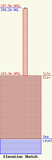
| Elevation Info |
Site Elevation: 143.3 meters (470 ft) |
| Height of Structure: 152.4 meters (500 feet) |
| Overall Height Above Ground: 154.2 meters (506 feet) |
| Overall Height Above Mean Sea Level: 297.5 meters (976 feet) |
| Owner Info | Global Signal Acquisitions LLC
2000 Corporate Drive
Canonsburg, PA 15317
(724) 416-2400
Regulatory.Department@crowncastle.com |
| Contact Info | Crown Castle
2000 Corporate Drive
Canonsburg, PA 15317
Tom Anderson
(724) 743-6330
Tom.Anderson@crowncastle.com |
