|
|
Antenna Structure Registration 1017402 |
 |
Registration Info | Registration Number: 1017402 |
| File Number: A1048648 |
| Status: Constructed |
| Date Constructed: 01/01/1970 |
| NEPA: N |
Structure Info
| Structure Type: TOWER |
| Structure Coordinates: 44-27-3.0 N 73-11-49.0 W (NAD 83) |
| Structure Coordinates: 44-27-02.8 N 73-11-50.5 W (Converted to NAD 27) |
| Structure Address: 70 Joy Dr |
| Structure City: Burlington, VT |
| Structure County: Chittenden County |
| Painting & Lighting Info |
FCC Paragraph(s): 1, 3, 12, 21 |
| Elevation Info |
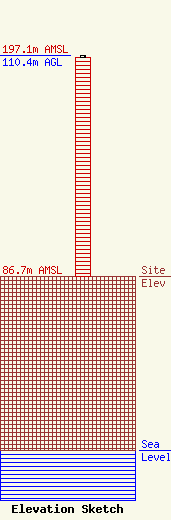
Site Elevation: 86.7 meters (284 ft) |
| Height of Structure: 109.4 meters (359 feet) |
| Overall Height Above Ground: 110.4 meters (362 feet) |
| Overall Height Above Mean Sea Level: 197.1 meters (647 feet) |
| Owner Info | Hall Communications, Inc.
1996 Auction Road
Manheim, PA 17545
(717) 653-0800
arowbotham@hallradio.net |
| Contact Info | Hall Communications, Inc.
1996 Auction Road
Manheim, PA 17545
Edd Monskie
(717) 653-0800
emonskie@hallradio.net |
