|
|
Antenna Structure Registration 1017602 |
 |
Registration Info | Registration Number: 1017602 |
| File Number: A1317837 |
| FAA Study: 2025-ACE-529-OE |
| FAA Issue Date: 04/10/2025 |
| Status: Constructed |
| Date Constructed: 06/10/2025 |
| NEPA: N |
Structure Info
| Structure Type: GTOWER |
| Structure Coordinates: 42-18-58.5 N 91-51-31.0 W (NAD 83) |
| Structure Coordinates: 42-18-58.5 N 91-51-30.4 W (Converted to NAD 27) |
| Structure Address: 2113 330th Street |
| Structure City: Walker, IA |
| Structure County: Buchanan County |
| Painting & Lighting Info |
FAA Circular #: 70/7460-1M |
FAA Chapters: 3, 4, 5, 15 |
Remarks: PRIOR STUDY 1973-ACE-597-OE |
| Elevation Info |
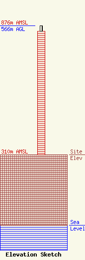
Site Elevation: 310 meters (1017 ft) |
| Height of Structure: 543.5 meters (1783 feet) |
| Overall Height Above Ground: 566 meters (1857 feet) |
| Overall Height Above Mean Sea Level: 876 meters (2874 feet) |
| Owner Info | Gray Local Media, Inc.
4370 Peachtree Road, NE
Atlanta, GA 30319
(404) 266-8333
legalnotices@graymedia.com |
| Contact Info | Gray Local Media, Inc.
4370 Peachtree Road NE
Atlanta, GA 30319
(404) 266-8333
legalnotices@graymedia.com |
