|
|
Antenna Structure Registration 1017605 |
 |
Registration Info | Registration Number: 1017605 |
| File Number: A1328694 |
| FAA Study: 2025-ASO-15563-OE |
| FAA Issue Date: 07/30/2025 |
| Status: Constructed |
| Date Constructed: 07/24/2025 |
| NEPA: N |
Structure Info
| Structure Type: LTOWER |
| Structure Coordinates: 30-18-48.2 N 81-38-58.3 W (NAD 83) |
| Structure Coordinates: 30-18-47.3 N 81-38-59.0 W (Converted to NAD 27) |
| Structure Address: 1851 Southampton Road |
| Structure City: Jacksonville, FL |
| Structure County: Duval County |
| Painting & Lighting Info |
FAA Circular #: 70/7460-1M |
FAA Chapters: 4, 8, 15 |
Remarks: PRIOR STUDY 1989-ASO-45-OE |
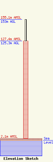
| Elevation Info |
Site Elevation: 2.1 meters (7 ft) |
| Height of Structure: 125.3 meters (411 feet) |
| Overall Height Above Ground: 153 meters (502 feet) |
| Overall Height Above Mean Sea Level: 155.1 meters (509 feet) |
| Owner Info | Graham Media Group, Florida, Inc.
c/o Graham Media Group
Detroit, MI 48226
(248) 983-5243
jmarshall@grahammedia.com |
| Contact Info | Brooks, Pierce et al.
150 Fayetteville Street
Raleigh, NC 27601
Patrick Cross
(919) 839-0300
pcross@brookspierce.com |
