|
|
Antenna Structure Registration 1017920 |
 |
Registration Info | Registration Number: 1017920 |
| File Number: A0938684 |
| FAA Study: 2013-AEA-7485-OE |
| FAA Issue Date: 03/03/2014 |
| Status: Constructed |
| Date Constructed: 12/01/2014 |
| NEPA: N |
Structure Info
| Structure Type: GTOWER |
| Structure Coordinates: 37-12-33.7 N 76-32-32.2 W (NAD 83) |
| Structure Coordinates: 37-12-33.2 N 76-32-33.4 W (Converted to NAD 27) |
| Structure Address: 100 Tower Ln |
| Structure City: Yorktown, VA |
| Structure County: York County |
| Painting & Lighting Info |
FCC Paragraph(s): 1, 3, 4, 13, 21 |
Remarks: PRIOR STUDY 2001-AEA-975-OE |
Remarks: Continue As Is OM&L = PAINT/RED LIGHTS |
Remarks: PRIOR STUDY 2001-AEA-975-OE |
Remarks: Continue As Is OM&L = PAINT/RED LIGHTS |
| Elevation Info |
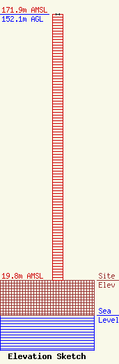
Site Elevation: 19.8 meters (65 ft) |
| Height of Structure: 152.1 meters (499 feet) |
| Overall Height Above Ground: 152.1 meters (499 feet) |
| Overall Height Above Mean Sea Level: 171.9 meters (564 feet) |
| Owner Info | NEWPORT NEWS, CITY OF
513 Oyster Point Road, Bldg Q
NEWPORT NEWS, VA 23602
(757) 269-2433
lboring@nngov.com |
| Contact Info | NEWPORT NEWS, CITY OF
513 Oyster Point Road, Bldg Q
NEWPORT NEWS, VA 23602
(757) 269-2433
lboring@nngov.com |
