|
|
Antenna Structure Registration 1017996 |
 |
Registration Info | Registration Number: 1017996 |
| File Number: A1279471 |
| FAA Study: 2023-ASO-31407-OE |
| FAA Issue Date: 01/29/2024 |
| Status: Constructed |
| Date Constructed: 03/12/2024 |
| NEPA: N |
Structure Info
| Structure Type: GTOWER |
| Structure Coordinates: 36-31-36.8 N 82-35-12.7 W (NAD 83) |
| Structure Coordinates: 36-31-36.4 N 82-35-13.2 W (Converted to NAD 27) |
| Structure Address: 1631 Bays Mountain Park Road |
| Structure City: Kingsport, TN |
| Structure County: Sullivan County |
| Painting & Lighting Info |
FAA Circular #: 70/7460-1M |
FAA Chapters: 4, 6, 15 |
Remarks: PRIOR STUDY 2012-ASO-11552-OE |
| Elevation Info |
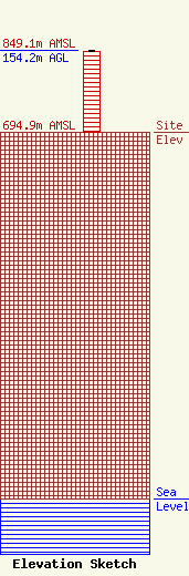
Site Elevation: 694.9 meters (2280 ft) |
| Height of Structure: 152.4 meters (500 feet) |
| Overall Height Above Ground: 154.2 meters (506 feet) |
| Overall Height Above Mean Sea Level: 849.1 meters (2786 feet) |
| Owner Info | HOLSTON VALLEY BROADCASTING CORPORATION
222 COMMERCE STREET
KINGSPORT, TN 37660
(423) 246-9578
davidw@wtfm.com |
| Contact Info | HOLSTON VALLEY BROADCASTING CORPORATION
222 COMMERCE STREET
KINGSPORT, TN 37660
David Widener
(423) 246-9578
davidw@wtfm.com |
