|
|
Antenna Structure Registration 1018044 |
 |
Registration Info | Registration Number: 1018044 |
| File Number: A0529513 |
| FAA Study: 92-AEA-0433-OE |
| FAA Issue Date: 08/28/1992 |
| Status: Constructed |
| Date Constructed: 01/01/1992 |
| FAA EMI: N |
| NEPA: N |
Structure Info
| Structure Type: TOWER |
| Structure Coordinates: 38-53-44.0 N 77-8-3.0 W (NAD 83) |
| Structure Coordinates: 38-53-43.6 N 77-08-04.1 W (Converted to NAD 27) |
| Structure Address: Sw Corner Lee Hwy & G M Dr |
| Structure City: Arlington, VA |
| Structure County: Arlington County |
| Painting & Lighting Info |
FAA Circular #: 70/7460-1G |
FAA Chapters: 3, 4, 5, 9 |
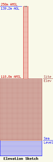
| Elevation Info |
Site Elevation: 118.8 meters (390 ft) |
| Height of Structure: 139.2 meters (457 feet) |
| Overall Height Above Ground: 139.2 meters (457 feet) |
| Overall Height Above Mean Sea Level: 258 meters (846 feet) |
| Owner Info | WAVA Building Limited Partnership
4922-A St. Elmo Avenue
Bethesda, MD 20814
(301) 654-2100
amoler@lenkin.com |
| Contact Info | WAVA Building Limited Partnership
4922-A St. Elmo Avenue
Bethesda, MD 20814
Al Moler
(301) 654-2100
amoler@lenkin.com |
