|
|
Antenna Structure Registration 1018206 |
 |
Registration Info | Registration Number: 1018206 |
| File Number: A1152811 |
| FAA Study: 2017-AEA-4446-OE |
| FAA Issue Date: 05/05/2017 |
| Status: Constructed |
| Date Constructed: 01/01/1967 |
| NEPA: N |
Structure Info
| Structure Type: GTOWER |
| Structure Coordinates: 38-36-3.9 N 78-37-56.8 W (NAD 83) |
| Structure Coordinates: 38-36-03.5 N 78-37-57.7 W (Converted to NAD 27) |
| Structure Address: Massanutten Mountain 6.2 Km Sw Luray |
| Structure City: Luray, VA |
| Structure County: Page County |
| Painting & Lighting Info |
FAA Circular #: 70/7460-1L |
FAA Chapters: 4, 8, 12 |
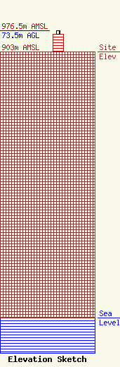
| Elevation Info |
Site Elevation: 903 meters (2963 ft) |
| Height of Structure: 61.3 meters (201 feet) |
| Overall Height Above Ground: 73.5 meters (241 feet) |
| Overall Height Above Mean Sea Level: 976.5 meters (3204 feet) |
| Owner Info | Shenandoah Valley Electric Cooperative
180 Oakwood Drive
236
Mt Crawford, VA 22841
(540) 574-7244
rpope@svec.coop |
| Contact Info | Shenandoah Valley Electric Cooperative
180 Oakwood Drive
236
Mt Crawford, VA 22841
Ray Pope
(540) 574-7244
rpope@svec.coop |
