|
|
Antenna Structure Registration 1018222 |
 |
Registration Info | Registration Number: 1018222 |
| File Number: A1169101 |
| FAA Study: 2019-AEA-5099-OE |
| FAA Issue Date: 05/06/2019 |
| Status: Constructed |
| Date Constructed: 06/15/2019 |
| NEPA: N |
Structure Info
| Structure Type: GTOWER |
| Structure Coordinates: 37-59-0.0 N 78-29-1.0 W (NAD 83) |
| Structure Coordinates: 37-58-59.5 N 78-29-02.0 W (Converted to NAD 27) |
| Structure Address: Carters Mountain 3.1 Mi S |
| Structure City: Charlottesville, VA |
| Structure County: Albemarle County |
| Painting & Lighting Info |
FAA Circular #: 70/7460-1L |
FAA Chapters: 4, 8, 12 |
Remarks: PRIOR STUDY 1997-AEA-898-OE |
| Elevation Info |
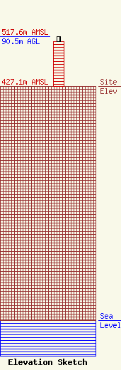
Site Elevation: 427.1 meters (1401 ft) |
| Height of Structure: 81.7 meters (268 feet) |
| Overall Height Above Ground: 90.5 meters (297 feet) |
| Overall Height Above Mean Sea Level: 517.6 meters (1698 feet) |
| Owner Info | VPM Media Corporation
23 Sesame Street
Richmond, VA 23235
(804) 560-8153
mspiller@vpm.org |
| Contact Info | Wiley Rein LLP
1776 K Street, N.W.
Washington, DC 20006
Ari Meltzer
(202) 719-7467
ameltzer@wiley.law |
