|
|
Antenna Structure Registration 1018563 |
 |
Registration Info | Registration Number: 1018563 |
| File Number: A1005408 |
| FAA Study: 2016-AWP-3100-OE |
| FAA Issue Date: 05/02/2016 |
| Status: Granted |
| Date Constructed: 03/08/2000 |
| NEPA: N |
Structure Info
| Structure Type: GTOWER |
| Structure Coordinates: 34-19-49.0 N 119-1-27.4 W (NAD 83) |
| Structure Coordinates: 34-19-49.0 N 119-01-24.0 W (Converted to NAD 27) |
| Structure Address: South Mountain 4.2 Km Se |
| Structure City: Santa Paula, CA |
| Structure County: Ventura County |
| Painting & Lighting Info |
FAA Circular #: 70/7460-1J |
FAA Chapters: 3, 4, 5, 13 |
Remarks: PRIOR STUDY 1999-AWP-2243-OE |
Remarks: OM&L to remain the same as prior study = PAINT/RED LIGHTS |
Remarks: PRIOR STUDY 1999-AWP-2243-OE |
Remarks: OM&L to remain the same as prior study = PAINT/RED LIGHTS |
| Elevation Info |
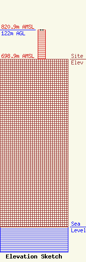
Site Elevation: 698.9 meters (2293 ft) |
| Height of Structure: 122 meters (400 feet) |
| Overall Height Above Ground: 122 meters (400 feet) |
| Overall Height Above Mean Sea Level: 820.9 meters (2693 feet) |
| Owner Info | Ventura, County of
800 South Victoria Avenue L#1100
Ventura, CA 93009
(805) 901-0448
Scott.Allison@Ventura.org |
| Contact Info | Holbrow Associates
3603 Castle Rock Road
Diamond Bar, CA 91765
Willmore Holbrow
(909) 595-3020
Holbrow@att.net |
