|
|
Antenna Structure Registration 1018770 |
 |
Registration Info | Registration Number: 1018770 |
| File Number: A0553714 |
| FAA Study: 2006-ASO-3421-OE |
| FAA Issue Date: 06/13/2006 |
| Status: Constructed |
| Date Constructed: 11/01/2006 |
| FAA EMI: N |
| NEPA: N |
Structure Info
| Structure Type: TOWER |
| Structure Coordinates: 32-47-51.0 N 86-34-8.0 W (NAD 83) |
| Structure Coordinates: 32-47-50.5 N 86-34-08.1 W (Converted to NAD 27) |
| Structure Address: 5898 Cr 41 |
| Structure City: Clanton, AL |
| Structure County: Chilton County |
| Painting & Lighting Info |
FAA Circular #: 70/7460-1K |
FAA Chapters: 4, 8, 12 |
Remarks: PRIOR STUDY 1991-ASO-1681-OE |
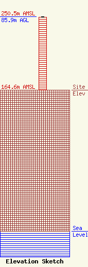
| Elevation Info |
Site Elevation: 164.6 meters (540 ft) |
| Height of Structure: 85.3 meters (280 feet) |
| Overall Height Above Ground: 85.9 meters (282 feet) |
| Overall Height Above Mean Sea Level: 250.5 meters (822 feet) |
| Owner Info | ALABAMA, STATE OF
PO DRAWER 2160
CLANTON, AL 35046-2160
(205) 280-2288
|
