|
|
Antenna Structure Registration 1019039 |
 |
Registration Info | Registration Number: 1019039 |
| File Number: A0484069 |
| Status: Constructed |
| Date Constructed: 01/01/1967 |
| FAA EMI: N |
| NEPA: N |
Structure Info
| Structure Type: TOWER |
| Structure Coordinates: 36-57-48.0 N 76-24-41.0 W (NAD 83) |
| Structure Coordinates: 36-57-47.5 N 76-24-42.2 W (Converted to NAD 27) |
| Structure Address: Newport News Point S End Of Jefferson Ave |
| Structure City: Newport News, VA |
| Structure County: Newport News city |
| Painting & Lighting Info |
FCC Paragraph(s): 1, 3, 12, 21 |
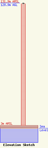
| Elevation Info |
Site Elevation: 3 meters (10 ft) |
| Height of Structure: 127.9 meters (420 feet) |
| Overall Height Above Ground: 128.9 meters (423 feet) |
| Overall Height Above Mean Sea Level: 131.9 meters (433 feet) |
| Owner Info | MHR Licence LLC
900 Laskin Road
Virginia Beach, VA 23451
(757) 437-9800
dwilhelm@maxmediallc.com |
| Contact Info | Williams Mullen, A Professional Corporation
1666 K St., NW, Suite 1200
Washington, DC 20006
Julian Shepard
(202) 833-9200
jshepard@williamsmullen.com |
