|
|
Antenna Structure Registration 1019567 |
 |
Registration Info | Registration Number: 1019567 |
| File Number: A0586736 |
| FAA Study: ATL-OE-67-559 |
| FAA Issue Date: 12/07/1967 |
| Status: Constructed |
| Date Constructed: 05/01/1968 |
| FAA EMI: N |
| NEPA: N |
Structure Info
| Structure Type: TOWER |
| Structure Coordinates: 33-30-0.0 N 81-56-2.0 W (NAD 83) |
| Structure Coordinates: 33-29-59.5 N 81-56-02.6 W (Converted to NAD 27) |
| Structure Address: 104 Bennett La |
| Structure City: North Augusta, SC |
| Structure County: Aiken County |
| Painting & Lighting Info |
FCC Paragraph(s): 1, 3, 11, 21 |
Remarks: RED LIGHTS/PAINT |
| Elevation Info |
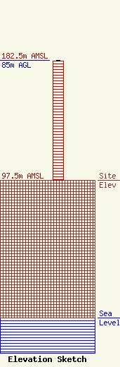
Site Elevation: 97.5 meters (320 ft) |
| Height of Structure: 84.1 meters (276 feet) |
| Overall Height Above Ground: 85 meters (279 feet) |
| Overall Height Above Mean Sea Level: 182.5 meters (599 feet) |
| Owner Info | Perry Broadcasting of Augusta, Inc.
1528 NE 23rd Street
Oklahoma City, OK 73111
(405) 424-4695
|
| Contact Info | DeBee Gilchrist, P.C.
100 N. Broadway, Suite 1500
Oklahoma City, OK 73102
H. Edward DeBee
(405) 232-7777
edebee@debeegilchrist.com |
