|
|
Antenna Structure Registration 1020297 |
 |
Registration Info | Registration Number: 1020297 |
| File Number: A0024258 |
| FAA Study: 97-ASO-0118-OE |
| FAA Issue Date: 02/04/1997 |
| Status: Granted |
| NEPA: N |
Structure Info
| Structure Type: TOWER |
| Structure Coordinates: 31-15-49.0 N 85-18-24.0 W (NAD 83) |
| Structure Coordinates: 31-15-48.4 N 85-18-24.2 W (Converted to NAD 27) |
| Structure Address: Approx 3.2 Km W |
| Structure City: Webb, AL |
| Structure County: Houston County |
| Painting & Lighting Info |
FAA Circular #: 70/7460-1J |
FAA Chapters: 3, 4, 5, 13 |
| Elevation Info |
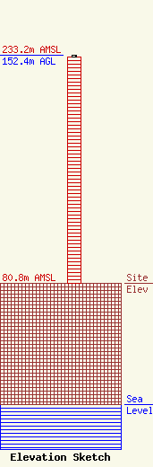
Site Elevation: 80.8 meters (265 ft) |
| Height of Structure: 151.4 meters (497 feet) |
| Overall Height Above Ground: 152.4 meters (500 feet) |
| Overall Height Above Mean Sea Level: 233.2 meters (765 feet) |
| Owner Info | GULF SOUTH COMMUNICATIONS INC DBA = WDJR RADIO
2236 MONTGOMERY HWY
DOTHAN, AL 36304
(334) 712-1182
|
