|
|
Antenna Structure Registration 1020642 |
 |
Registration Info | Registration Number: 1020642 |
| File Number: A1141413 |
| FAA Study: 90-ASW-1838-OE |
| FAA Issue Date: 01/22/1991 |
| Status: Constructed |
| Date Constructed: 09/20/1991 |
| NEPA: N |
Structure Info
| Structure Type: TOWER |
| Structure Coordinates: 30-0-21.0 N 90-28-0.0 W (NAD 83) |
| Structure Coordinates: 30-00-20.3 N 90-27-59.7 W (Converted to NAD 27) |
| Structure Address: 1.2 Km S La Hwy 628 & Saint Charles Parish Boundary |
| Structure City: Montz, LA |
| Structure County: St. Charles Parish |
| Painting & Lighting Info |
FAA Circular #: 70/7460-1G |
FAA Chapters: 3, 4, 5, 9 |
| Elevation Info |
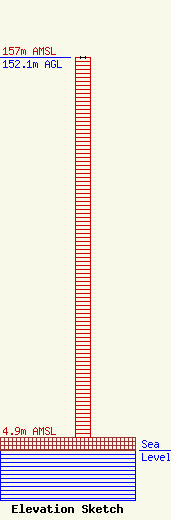
Site Elevation: 4.9 meters (16 ft) |
| Height of Structure: 152.1 meters (499 feet) |
| Overall Height Above Ground: 152.1 meters (499 feet) |
| Overall Height Above Mean Sea Level: 157 meters (515 feet) |
| Owner Info | Entergy Services, LLC
425 West Capitol Ave.
551
Little Rock, AR 72203-0551
(501) 377-5609
TelecomMgr@Entergy.com |
| Contact Info | Entergy Services, LLC
425 West Capitol Ave.
551
Little Rock, AR 72203-0551
Steven Paquette
(501) 377-5609
TelecomMgr@Entergy.com |
