|
|
Antenna Structure Registration 1020782 |
 |
Registration Info | Registration Number: 1020782 |
| File Number: A1230726 |
| FAA Study: 2021-ASO-43673-OE |
| FAA Issue Date: 11/01/2022 |
| Status: Constructed |
| Date Constructed: 07/01/2008 |
| NEPA: N |
Structure Info
| Structure Type: LTOWER |
| Structure Coordinates: 26-47-59.7 N 80-4-31.7 W (NAD 83) |
| Structure Coordinates: 26-47-58.5 N 80-04-32.5 W (Converted to NAD 27) |
| Structure Address: 1115 Old Dixie Hwy (302758) |
| Structure City: W. Palm Beach, FL |
| Structure County: Palm Beach County |
| Painting & Lighting Info |
FAA Circular #: 70/7460-1M |
FAA Chapters: 4, 6, 15 |
Remarks: PRIOR STUDY 2011-ASO-5311-OE |
| Elevation Info |
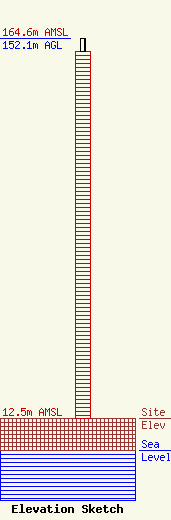
Site Elevation: 12.5 meters (41 ft) |
| Height of Structure: 146.9 meters (482 feet) |
| Overall Height Above Ground: 152.1 meters (499 feet) |
| Overall Height Above Mean Sea Level: 164.6 meters (540 feet) |
| Owner Info | American Towers, LLC
10 Presidential Way
Woburn, MA 01801
(781) 926-4500
faa-fcc@americantower.com |
| Contact Info | American Towers, LLC
10 Presidential Way
Woburn, MA 01801
(781) 926-4500
faa-fcc@americantower.com |
