|
|
Antenna Structure Registration 1020854 |
 |
Registration Info | Registration Number: 1020854 |
| File Number: A1137281 |
| FAA Study: 92-ASW-1579-OE |
| Status: Constructed |
| Date Constructed: 10/15/1992 |
| NEPA: N |
Structure Info
| Structure Type: TOWER |
| Structure Coordinates: 30-2-55.0 N 91-59-49.0 W (NAD 83) |
| Structure Coordinates: 30-02-54.3 N 91-59-48.6 W (Converted to NAD 27) |
| Structure Address: 1830 Guilliot Rd 3.2 Mi S |
| Structure City: Youngsville, LA |
| Structure County: Vermilion Parish |
| Painting & Lighting Info |
FAA Circular #: 70/7460-1H |
FAA Chapters: 3, 4, 5, 13 |
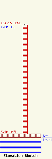
| Elevation Info |
Site Elevation: 6.1 meters (20 ft) |
| Height of Structure: 178 meters (584 feet) |
| Overall Height Above Ground: 178 meters (584 feet) |
| Overall Height Above Mean Sea Level: 184.1 meters (604 feet) |
| Owner Info | Telcom Properties
701 S Martin Luther King Hwy.
19084
LAKE CHARLES, LA 70615
(337) 436-7573
pdv@lrcwireless.com |
| Contact Info | Telcom Properties
701 S Martin Luther King Hwy.
19084
LAKE CHARLES, LA 70615
(337) 436-7573
pdv@lrcwireless.com |
