|
|
Antenna Structure Registration 1020875 |
 |
Registration Info | Registration Number: 1020875 |
| File Number: A0696734 |
| Status: Constructed |
| Date Constructed: 01/01/1927 |
| FAA EMI: N |
| NEPA: N |
Structure Info
| Structure Type: 2TA1 |
| Structure Coordinates: 45-43-34.0 N 108-36-37.0 W (NAD 83) |
| Structure Coordinates: 45-43-34.2 N 108-36-34.5 W (Converted to NAD 27) |
| Structure Address: Twr 1 - 7730 Laurel Frontage Rd |
| Structure City: Billings, MT |
| Structure County: Yellowstone County |
| Painting & Lighting Info |
FCC Paragraph(s): 1, 3, 4, 13, 21 |
| Elevation Info |
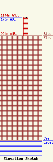
Site Elevation: 974 meters (3196 ft) |
| Height of Structure: 169 meters (554 feet) |
| Overall Height Above Ground: 170 meters (558 feet) |
| Overall Height Above Mean Sea Level: 1144 meters (3753 feet) |
| Owner Info | R & M TOWERS
7730 LAUREL FRONTAGE ROAD
BILLINGS, MT 59101
ROBERT ROBERTS
(406) 656-2939
bmaher@vermeermt.com |
| Info |
